
Work a Temple Street Directory Step by Step
A Temple street search begins with the physical address, then moves through sources that answer different questions. Bell CAD can anchor the parcel and its situs label. The map can show the road alignment and adjacent parcels. Bell County's recorded-property index can then supply the legal transfer trail. An official voter lookup is useful for a person checking that person's own registration status, while dated directories and maps can supply a past address association. Keep each result in its own lane: a parcel is not an occupant list, a deed is not a current-residence statement, and a directory is a time-stamped publication.
- Enter the street number and name in Bell CAD's By Address mode, saving the property or geographic ID, situs, subdivision, and tax-year label.
- Open the Bell CAD Interactive Maps route to compare the selected parcel with the road and nearby parcel polygons.
- Use the owner or legal-description clues to search Bell County recorded property records by grantor, grantee, subdivision, instrument number, or recorded-date range.
- Check the official Texas registration-status route only for the limited voter-status purpose it provides, and do not treat election activity as proof of a current home.
- For a historical Temple address, compare the lot or block with dated directories, newspapers, and Sanborn map sheets before drawing a household conclusion.
That sequence makes the street directory useful because it records both what each source says and what it cannot say. If two labels conflict, preserve the conflict with the source date rather than silently choosing one.
Temple Street Directory Fields in Bell CAD
The inspected Bell CAD property search offers Search, By Owner, By Address, By ID, ARB Search, and Advanced Search. Its address work is deliberately narrower than a broad name search. When address matching fails, Bell CAD advises trying a street name without a prefix, suffix, or unit. Autocomplete fields may require selecting a result from the dropdown and then pressing the separate Search control. The site also says its legal-description and acreage information is for research and should be verified for legal purposes.
| Bell CAD path | Observed fields | Useful Temple street input | Important limit |
|---|---|---|---|
| By Address | Street number and street name | Exact number and name, then a stripped street name if needed | No visible ZIP field was inspected |
| By Owner | Owner name | Last Name First Name | Owner data does not establish occupancy |
| By ID | Property ID and geographic ID | Reuse an ID found in an address result | An account key is not a resident identifier |
| Advanced Search | DBA, property type, status, tax year, abstract, subdivision, condo, neighborhood | Use a subdivision or neighborhood as a secondary locator | Visible tax years were 2026, 2025, and 2024; no full historical range was stated |
The public Bell CAD screen pictured here is the appropriate starting point for an address anchor, not a substitute for a title document or a statement about a household.
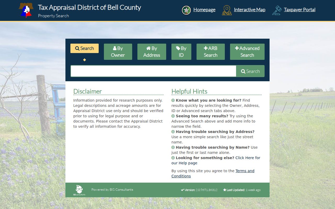
The tabs and field grid show why a Temple street query should be recorded with the exact mode used: address, owner, ID, and advanced inputs lead to different kinds of parcel evidence.
Temple Records Reachable by Street or Address
Address-keyed work in Temple is strongest when the record set is named before it is searched. Bell CAD supplies appraisal and parcel context. The Clerk maintains recorded instruments. Bell Elections and the Secretary of State provide official registration and precinct channels subject to confidentiality rules. Historic maps and printed directories provide dated context. None of these sources should be compressed into a single claim that a particular person lives at an address.
| Address-linked source | Temple or Bell custodian | What the source can show | Access route |
|---|---|---|---|
| Property appraisal record | Bell CAD | Owner of record, situs, mailing line, legal description, parcel identifiers, and tax-year context | Online search; Temple office is listed at 205 E. Central Ave. |
| Parcel map | Bell CAD Interactive Maps | Parcel polygons, road alignment, and map relationships | Official linked viewer; dynamic layer names should be checked live |
| Recorded instruments | Bell County Clerk | Grantor, grantee, subdivision, document type, instrument number, and recorded date | SuperSearch/OCR, CountyFusion, recording staff, or a specific records request |
| Registration and precinct context | Bell County Elections and Texas SOS | Official status route, precinct map, and public-information rules | Texas SOS lookup; protected residential addresses must not be republished |
| Historic street evidence | Maps, directories, newspapers, and deeds | Structure, annual address association, publication context, or legal transfer | Collection-specific access and date-aware comparison |
For an instrument, begin with the index and then read the image. Bell County cautions that its convenience information is not certified or authenticated, so a legal record should be verified with the Clerk.
Temple Parcels Along a Street in the GIS Viewer
Bell CAD Interactive Maps is the official linked parcel-map route. A careful Temple workflow is to locate the address or parcel, turn on parcel, road, or orthophoto layers if they are offered in the live viewer, select an adjacent polygon, and record a property or geographic ID. Return to CAD for the authoritative account rather than assuming the map popup answers every question. The research did not expose a fixed live layer list, historical-imagery date, export control, or measurement setting, so those items need a retrieval-date note when used.
GIS is especially helpful for checking whether a street label, parcel shape, and road alignment agree. It is a visual relation tool, not proof that an owner record names every person connected with a site. Bell CAD's reappraisal-plan material describes cadastral maps, aerial imagery, and related layers, but the cited district-wide account figure is not a Temple parcel count.
Temple Street Labels, Parcels, and Legal Descriptions
Several terms travel together in a Temple address search, but they do not mean the same thing. A situs is the physical location assigned to a parcel. A mailing address is where appraisal correspondence goes and can be outside Temple or Bell County. A deed's legal description may retain a lot, block, abstract, or metes-and-bounds reference that remains useful when a street label has changed. Treat the property or geographic ID as a search key, not as information to publish simply because it is available.
- Parcel
- A mapped unit of property appraisal. Its outline supports location research but does not identify a household.
- Situs address
- The physical address assigned to the property. It is an anchor for a Temple street directory search, not proof of present occupancy.
- Plat
- A recorded plan that can establish lots, blocks, and street names without naming a resident.
- Criss-cross directory
- A reverse address-style directory used as dated printed evidence of an address association when a verified run is available.
Temple Street Numbers Can Change Over Time
Temple street numbers can change after platting, subdivision work, roadway projects, annexation, addressing correction, or a rural route's conversion into a named street. Older material may instead cite a lot and block, a nearby cross street, a business name, or a pre-numbering road name. Search current and older spellings, suffix variants, and directional abbreviations. When a permit and a deed use different numbers, preserve both labels with their dates and use the legal description to test the connection.
This is also where an annual directory and a Sanborn index can help. A modern number may not exist in the earliest local sources, and a street name alone can be too broad. The sensible question is whether several dated sources point to the same block or parcel, not whether one modern label settles the history.
Temple Street Searches Need a Careful ZIP Label
USPS delivery geography, Bell CAD parcel geography, Temple city limits, and Census geography have separate roles. Research observed current PostalPro associations for 76501, 76502, and 76508 with Temple TX 76501, while archived USPS material lists a broader historical Temple grouping. A ZIP line does not establish the municipal boundary or parcel jurisdiction. For a street result, retain the CAD situs and mailing line separately, then confirm an active postal label through current USPS material.
Bell CAD's inspected form has no visible ZIP field. A Temple query that begins with a ZIP therefore needs a postal or ZCTA boundary step followed by address, parcel, or GIS research. It is safer to label the mode used, such as USPS postal ZIP or CAD address search, than to merge unlike geographies into one list.
Temple Street Directory Clues in 1893 and 1922 Maps
For a historic block, the 1893 Temple Sanborn set at the Library of Congress has eight sheets, and the University of Texas record identifies a 1922 item as sheet 18. Those sheet references make a comparison reproducible. A Sanborn map records building and fire-risk context; it does not identify a modern resident. Pair it with a deed, a dated directory entry, or a newspaper item before stating an address association.
Temple's early record trail also reflects its Santa Fe founding in 1881, MKT arrival and incorporation in 1882, and the early nickname “Tanglefoot.” Those details are useful historical search terms for an 1880s street or block, not evidence about a current address. Readers seeking the directory collections themselves can use the Temple city directory page after the parcel and map work is defined.
Temple Street Directory Results: Owner Is Not Occupant
Bell CAD may show an owner of record, a situs address, a mailing address, a legal description, acreage, valuation fields, exemptions, tax status, and appraisal identifiers. A parcel can be held by a trust, estate, business, or several people. The mailing line can be elsewhere. A recorded deed identifies a title event, and its recording date may lag both execution and any change at the address. These are reasons to use precise labels such as “CAD owner data” and “recorded transfer,” rather than turning property evidence into a statement about who currently lives there.
The same caution applies to historical printed material. A directory connects an address with a publication date, while a map identifies a structure or use. Strong Temple research uses two or more suitable sources and states whether a conclusion is direct evidence or a limited inference.
Temple Street Directory Privacy Limits
A Temple street directory should be used for lawful personal research, family history, property context, and civic understanding. It should not expose protected residential addresses or turn parcel, voter, or map data into a list of private people. Texas voter rules can suppress residential addresses for eligible protected individuals, including Address Confidentiality Program participants. If a record shows a substitute or protected indicator, do not try to reconstruct a home location from another source.
Lawful use. Use address-linked records with care and source limits in mind. Never use this material to stalk, harass, intimidate, or harm another person.
Temple Street Directory Requests Beyond the Online Index
When the online index does not settle a recorded-property question, the Bell County Clerk offers more than one route. The recording division lists deed.recording@bellcounty.texas.gov and 254-933-5171. Requests can be mailed to PO Box 480, Attn Open Records Request, emailed to the Clerk, hand delivered, faxed where accepted, or submitted through an approved web route under Government Code §552.234. Ask for the exact instrument, names as indexed, date range, and whether a plain or certified copy is needed.
The Clerk's recorded property search shows the term, department, date-range, and index-plus-OCR controls that support a narrow Temple deed search.
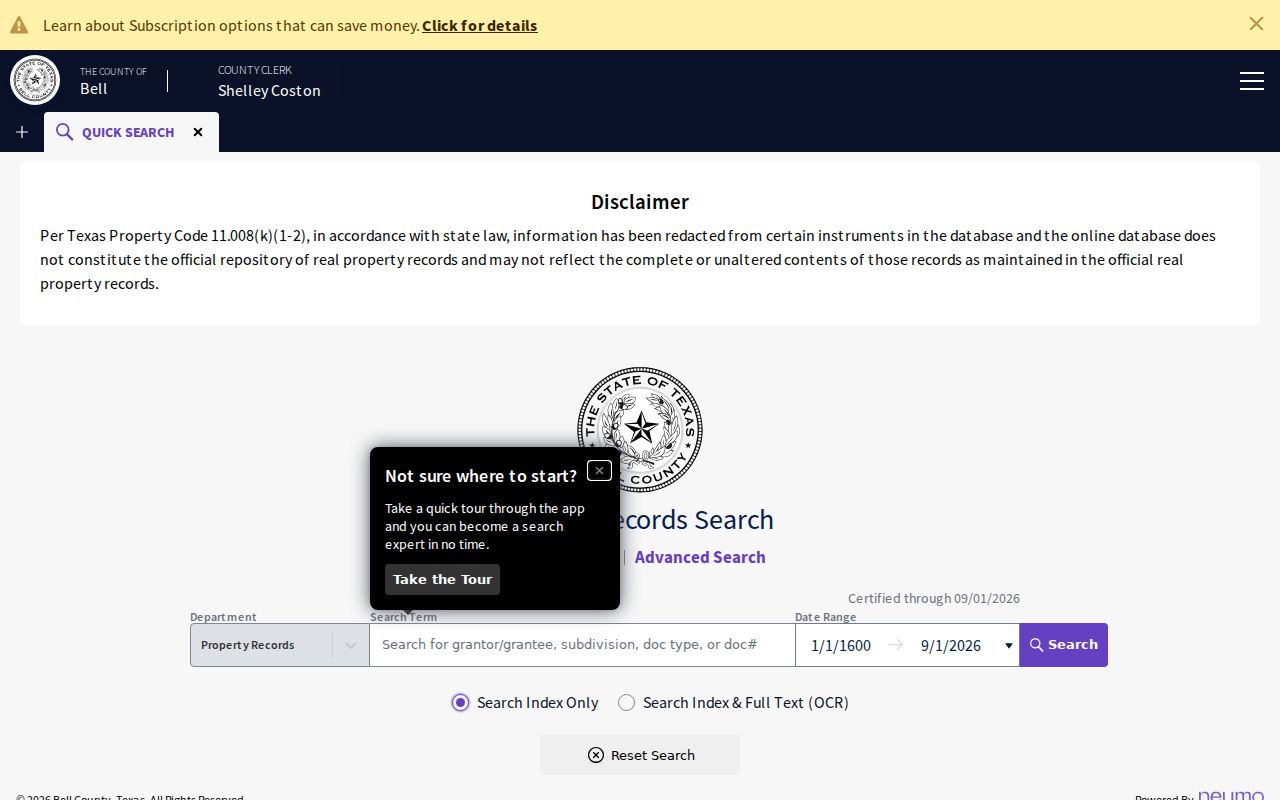
This record-index view helps identify an instrument to request or inspect; it does not replace reading the recorded image in the chain of title.
The Clerk's main office is in Belton, the county seat, and Temple has a County Clerk annex at 205 E. Central Ave. for some transactions. For recorded-property work, name the instrument instead of requesting everything connected with a person. The Clerk's search page lists copies at $1 per page under its stated schedule; confirm certified-copy terms and any order charges before relying on a current total.